The Italian Riviera’s crown jewel, Cinque Terre, offers some of the Mediterranean’s most spectacular coastal walking experiences. This UNESCO World Heritage site comprises five ancient fishing villages clinging to dramatic clifftops along the Ligurian coastline, connected by a network of historic trails that have served local communities for over a millennium. The region’s unique topography, characterised by steep terraced vineyards, medieval watchtowers, and crystalline azure waters, creates an unparalleled hiking destination that attracts over 2.5 million visitors annually.
These coastal paths weave through landscapes where ancient dry stone walls support centuries-old vineyards, and where every turn reveals breathtaking vistas of the Mediterranean Sea. The trails range from gentle seaside strolls to challenging mountain ascents, offering experiences suitable for casual walkers and seasoned trekkers alike. Whether you’re seeking romantic sunset walks or adventurous cliff-edge expeditions, Cinque Terre’s coastal trail network provides an unforgettable journey through one of Italy’s most photogenic regions.
Monterosso al mare coastal trail network: blue trail and sanctuary path integration
Monterosso al Mare, the largest and northernmost village of Cinque Terre, serves as the gateway to the region’s most extensive coastal trail network. The village’s strategic position offers access to both the famous Sentiero Azzurro (Blue Trail) and several high-altitude sanctuary paths that provide spectacular panoramic views. The integration of these routes creates opportunities for circular walks that combine coastal scenery with inland mountain vistas, making Monterosso an ideal base for comprehensive exploration of the region’s diverse landscapes.
The Blue Trail section from Monterosso to Vernazza represents one of the most challenging yet rewarding segments of the entire Cinque Terre coastal path. This 3.6-kilometre route typically requires approximately 90 minutes to complete, featuring significant elevation changes that test even experienced hikers. The path initially climbs steeply from Monterosso’s historic centre, ascending through terraced vineyards and olive groves before reaching the trail’s highest point at approximately 200 metres above sea level.
Via dell’amore alternative route through vineyard terraces
When the famous Via dell’Amore experiences seasonal closures, the vineyard terrace alternative provides an equally spectacular walking experience. This route climbs through ancient agricultural terraces that have shaped the landscape for over 800 years, offering intimate views of traditional Ligurian viticulture. The path requires moderate fitness levels and sturdy footwear, as the terrain includes narrow stone steps and potentially slippery surfaces during wet conditions.
The vineyard route showcases the ingenuity of medieval agriculture, where steep hillsides were transformed into productive farmland through the construction of thousands of kilometres of dry stone walls. These muri a secco represent one of humanity’s most impressive examples of landscape modification, creating microclimates that allow grape cultivation in seemingly impossible terrain. Hikers can observe traditional winemaking techniques still employed by local families whose vineyards have remained in the same families for generations.
Punta mesco promontory circuit via torre aurora lookout
The Punta Mesco circuit represents Cinque Terre’s most dramatic coastal walk, extending beyond the traditional village-to-village routes to explore the region’s wild northwestern headland. This challenging 8-kilometre circuit requires approximately 4 hours to complete and offers unparalleled views of the Ligurian coastline extending from the French Riviera to the Gulf of La Spezia. The route passes through the ancient Torre Aurora, a 16th-century watchtower that once served as an early warning system against Saracen raids.
The promontory trail showcases the region’s unique Mediterranean vegetation, including endemic plants that have adapted to the harsh coastal environment. During spring months, the path becomes a natural botanical garden featuring wild orchids, maritime pines, and aromatic herbs that perfume the sea air. The circuit’s challenging terrain includes rocky scrambles and exposed cliff sections that require careful navigation, particularly during windy conditions when the Mistral winds can create hazardous
gusts along the exposed ridgeline. For safety, this route is best attempted in stable weather conditions outside the hottest midday hours, and you should always carry sufficient water, as there are no reliable refill points once you leave Monterosso and the lower village streets behind.
Fegina beach to old town medieval quarter coastal connection
The coastal link between Fegina Beach and Monterosso’s medieval quarter offers one of the easiest yet most scenic short walks in Cinque Terre. Beginning on the broad, pebbly sands of Fegina, you follow the seafront promenade west towards the base of the rocky headland that divides the modern resort area from the historic village. The pedestrian tunnel that pierces this headland was blasted through in the early 20th century, transforming access between the two districts and creating a sheltered all-weather connection.
Emerging from the tunnel into the old town, you immediately encounter narrow caruggi (alleyways), striped Gothic churches, and traditional Ligurian houses stacked above tiny shops and cafés. This short coastal walk, which takes less than 15 minutes at a leisurely pace, is ideal for travellers who want to experience both Monterosso’s relaxed beach atmosphere and its medieval character without tackling steep ascents. At sunset, the promenade and tunnel frame spectacular views of the Ligurian Sea, making this route a favourite for evening strolls and casual photography.
Soviore sanctuary pilgrimage path from monterosso station
For a more demanding experience from Monterosso, the pilgrimage path to the Sanctuary of Nostra Signora di Soviore climbs from near the train station into the hills behind the village. This historic route, part of a wider network of sanctuary trails, ascends approximately 450 metres over 3.5 to 4 kilometres, requiring 2 to 2.5 hours for moderately fit hikers. The path alternates between ancient stone stairways, shaded forest tracks, and open sections where you can look back over the entire Cinque Terre coastline.
The Soviore Sanctuary itself is considered one of Liguria’s oldest Marian sanctuaries, with documented origins in the 13th century and probable earlier devotional use. Today, it offers a peaceful courtyard, a small church rich in votive offerings, and a rustic osteria where you can sample hearty local dishes after your climb. Many walkers choose to integrate this pilgrimage route with the high Sentiero Rosso ridge trail, descending later towards Vernazza or Levanto to create a full-day circular hike. Because of the sustained elevation gain, trekking poles and lightweight daypacks are particularly helpful on this route.
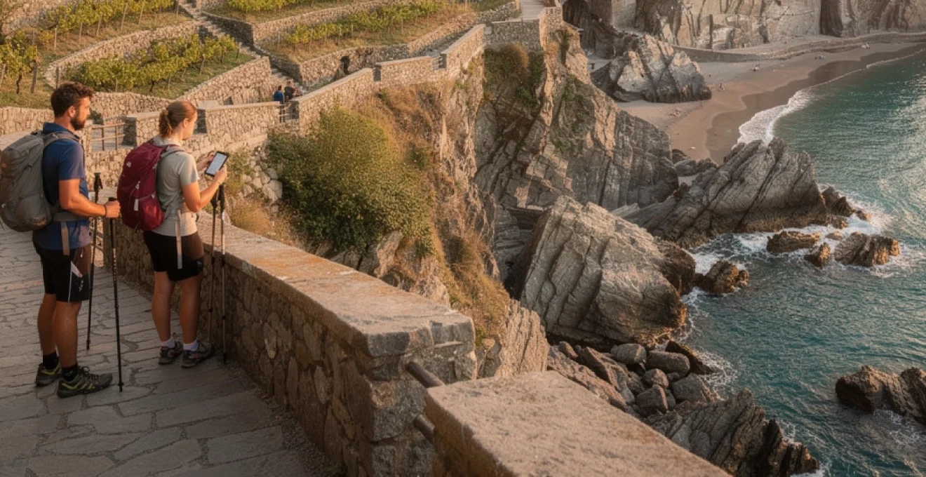
Vernazza to corniglia high trail: sentiero azzurro section analysis
The Vernazza to Corniglia section of the Sentiero Azzurro is widely regarded as one of the most photogenic coastal walks in Cinque Terre. Officially around 3.2 to 4 kilometres depending on minor route variations, it generally takes 90 to 120 minutes to complete and involves a cumulative elevation gain of approximately 220 metres. After leaving Vernazza’s harbour area, the trail rises steeply via stone steps through terraced vineyards, quickly rewarding your effort with expansive views back over the village and its distinctive Doria Castle tower.
This coastal segment exemplifies the classic Cinque Terre walking experience: narrow cliffside paths, hand-built dry stone walls, and glimpses of the railway tunnels far below. Because the trail can become congested during peak season, particularly in late morning and early afternoon, many experienced hikers recommend starting from Vernazza before 9 a.m. or walking the route later in the day when temperatures are milder. The path is officially classified as “medium difficulty,” meaning that while technical scrambling is not required, sure-footedness and a reasonable fitness level are essential.
Torre guardiola medieval watchtower navigation points
Although less famous than other fortifications, the area around Torre Guardiola provides valuable visual reference points for navigating the high trail between Vernazza and Corniglia. This former military lookout, located on the slopes above Vernazza, once formed part of a defensive chain of watchtowers along the Ligurian coast. From the main path, waymarked side spurs and viewpoints offer opportunities to orient yourself using the tower, Vernazza’s marina, and the outline of the Santa Margherita d’Antiochia church.
As you gain altitude, these landmarks function like a living topographic map, helping you track your progress while appreciating how geography shaped historical defence strategies. On clear days, you can see multiple villages aligned along the coast, a reminder of why such vantage points were vital in detecting pirate raids. When visibility is reduced by sea mist or low cloud—a common occurrence in spring and autumn—you should rely more on official trail markers and less on distant visual cues, reinforcing the importance of checking signage at each junction.
Prevo valley terraced vineyard traverse techniques
Midway between Vernazza and Corniglia, the path passes above the hamlet of Prevo, one of the highest coastal settlements in Cinque Terre at around 200 metres above sea level. Here, the trail threads its way through some of the region’s steepest terraced vineyards, where narrow stone walls support tiny plots of vines clinging to the hillside. Walking these sections can feel like balancing along the edge of a giant amphitheatre, with the Ligurian Sea shimmering far below.
To traverse this terrain safely, it is essential to maintain a steady, measured pace rather than rushing the steps and uneven surfaces. Think of your progress like moving along a narrow train platform: you stay alert to your footing, but you do not freeze or overthink each step. When passing other walkers on constricted stretches, it is courteous and safer for the uphill hiker to yield where possible, as they often have less visibility and momentum. During or after heavy rains, some of these terrace paths can become slick, so selecting footwear with aggressive tread and using trekking poles greatly improves stability.
Corniglia railway tunnel overhead cliff path methodology
As you approach Corniglia from Vernazza, the coastal trail crosses above the railway tunnel that links the villages deep within the cliff. This section, often referred to informally as the “railway balcony,” provides one of the most striking vantage points in the national park. From the path, you can look down to see train carriages briefly emerging from tunnels, then disappearing again into the rock, while Corniglia’s pastel houses perch 90 metres above sea level on their narrow promontory.
Because the path here is carved directly into steep slopes, it is essential to follow a simple methodology: keep to the inside of the trail wherever practical, avoid stopping at blind corners, and pause only at wider viewpoints where you are not obstructing traffic. Using these habits is a bit like adopting lane discipline on a mountain road—you move predictably, signal your intentions, and allow faster or more confident walkers to pass at safe points. In high season, park rangers may monitor this area to ensure that groups do not block the path, and temporary one-way systems can be implemented during maintenance operations.
Sponda beach access route via vernazza marina
While Vernazza is better known for its harbourfront promenade than for hiking, the access route to the small Sponda Beach offers a short but rewarding coastal detour. Starting from Piazza Marconi, you follow signs towards the marina and then take a series of stone steps leading along the rock face to a tiny, pebbly cove just beyond the main harbour. At low to moderate tide levels, this sheltered spot provides a rare opportunity to combine a coastal walk with a quick swim in relatively calm waters.
The path to Sponda Beach is narrow and occasionally wet from sea spray, so it is wise to wear shoes with good grip rather than flip-flops, especially if the rocks are slick. During peak summer, local authorities may restrict access if wave conditions are unsafe, underscoring the importance of reading any posted warnings at the marina. As an add-on to longer hikes, this short descent and ascent can serve as a cooling interlude, allowing you to experience the coastline at sea level before returning to the higher trails.
Manarola vineyard trails: UNESCO world heritage landscape routes
Manarola’s vineyard trails offer some of the most authentic and immersive walking experiences in Cinque Terre, showcasing the UNESCO-listed cultural landscape at close range. Unlike the main coastal routes, these paths wind horizontally along terrace lines above the village before gradually climbing into the hills, providing constantly changing angles of Manarola’s colourful houses and the open sea. Typical circuits range from 3 to 6 kilometres, with walking times of 1.5 to 3 hours depending on your chosen loop and the number of photo stops.
One of the most popular routes begins near the church of San Lorenzo, ascending on narrow lanes that transition into dirt paths among vines and olive trees. Along the way, you encounter small stone huts, monorail tracks used for transporting harvest crates, and informational panels explaining how the muri a secco maintain soil stability. Because these terraces are still actively cultivated, walkers are effectively guests in a vast open-air agricultural museum, and it is crucial to respect fences, avoid stepping on low walls, and never enter private plots without permission.
From the upper vineyard levels, you can connect to trail number 6d and other variants that trace the contours of the hillside, gradually returning towards Manarola via staircases that drop steeply back into the village. These descents can be demanding on the knees, particularly in hot conditions, so pacing yourself and using trekking poles can make a significant difference to comfort. If you time your walk for late afternoon, you are rewarded with golden light over the vineyards and the possibility of rounding off your hike with a glass of local Sciacchetrà dessert wine in one of Manarola’s cliffside bars.
Riomaggiore coastal path network: via beccara and love’s way alternatives
Riomaggiore, the southernmost of the Cinque Terre villages, anchors a compact but intricate network of coastal and hillside paths. Historically, the easiest seaside connection between Riomaggiore and Manarola was the Via dell’Amore, a paved cliffside promenade just over one kilometre long. However, ongoing landslide-related closures have made it essential for walkers to consider alternative routes that are more demanding but equally scenic, offering higher vantage points over the rugged coastline.
The principal alternative is the Via Beccara, a steep mountain path that climbs from the upper streets of Riomaggiore before dropping down towards Manarola. Covering roughly 2 to 3 kilometres depending on your exact start point, this trail includes more than 600 stone steps and an elevation gain of around 250 metres. It is a serious workout, but the reward is a series of panoramic viewpoints where you can see both villages framed by terraced hillsides and sheer cliffs plunging into the Ligurian Sea. Because the path is narrow in parts and exposed in others, it is best suited to hikers who are comfortable with heights and have solid footwear.
Within Riomaggiore itself, additional short coastal paths connect the bustling Via Colombo with the marina and rocky shoreline. These routes involve staircases, narrow underpasses, and occasional viewpoints where fishermen’s boats are pulled up onto ramps beneath the houses. Although they are brief, they provide valuable warm-up options before tackling longer ascents, as well as alternative sunset spots if the Via dell’Amore remains closed. Checking the latest trail status at the local information office or on the national park website is essential, as conditions and access rules can change with little notice following storms or maintenance works.
Advanced hiking equipment requirements for cinque terre terrain conditions
While many Cinque Terre walks are accessible to casual visitors, the region’s combination of steep gradients, exposed cliffs, and variable surfaces means that advanced equipment significantly enhances both safety and comfort. Unlike wide alpine trails, many of these routes are closer in character to traditional mule tracks—narrow, stepped, and sometimes eroded by rain and heavy foot traffic. As visitor numbers have grown, local authorities have repeatedly stressed that appropriate gear is not a luxury but a practical response to the terrain.
If you are planning to tackle multiple sections of the Sentiero Azzurro or higher routes like the Sentiero Rosso ridge trail, you should think of your packing list the way a sailor thinks about a ship’s rigging: every item has a purpose, and small oversights can have disproportionate consequences. Good footwear, weather-resistant clothing, basic navigation tools, and a well-organised daypack together form the core of a reliable hiking setup. In shoulder seasons, when sudden showers and temperature swings are common, this preparation can be the difference between an enjoyable coastal adventure and a difficult, potentially unsafe day on the trails.
Grip-enhanced footwear for limestone and schist rock formations
The geological foundation of Cinque Terre consists largely of layered schist and sandstone, interspersed with limestone outcrops that can become extremely slippery when wet. Ordinary city trainers or fashion sneakers often lack the grip and lateral support needed on such surfaces, particularly on uneven stone steps carved centuries ago. For coastal walks like Monterosso–Vernazza or Vernazza–Corniglia, low- to mid-cut hiking shoes with aggressive rubber tread are strongly recommended.
Look for footwear with a firm midsole, reinforced toe cap, and non-slip outsole designed for mixed rock and dirt terrain. A good analogy is the difference between road tyres and all-terrain tyres on a vehicle: both will move you forward, but only one gives you confidence when conditions deteriorate. If you plan to combine hiking with occasional swims or rocky beach access, consider packing lightweight water shoes as a secondary option rather than wearing sandals on the main trails. Closed footwear not only improves footing but also protects against sharp stones and loose gravel that are common on stepped descents.
Weather-resistant gear for mediterranean microclimatic variations
Cinque Terre’s Mediterranean climate may suggest endlessly sunny days, but the region is subject to rapid microclimatic changes due to its steep orography and proximity to open sea. Short, intense rainstorms, sudden gusts of wind, and temperature inversions are all possible, particularly in spring and autumn. For this reason, a lightweight, packable waterproof jacket with a hood is an essential item, even on days that begin with clear blue skies.
Layering is the most effective strategy for managing these variations: a breathable base layer, a light insulating mid-layer, and a shell that blocks wind and rain can be combined or removed as conditions shift. Think of your clothing system as adjustable blinds on a window—you open and close them gradually to keep internal conditions comfortable regardless of what is happening outside. In high summer, sun protection becomes equally critical, with a wide-brimmed hat, sunglasses with UV protection, and high-SPF sunscreen vital to prevent sunburn on exposed ridge sections where shade is limited.
Navigation tools for sentiero rosso high-altitude sections
Although the main coastal paths in Cinque Terre are well signposted, higher-altitude sections of the Sentiero Rosso and intersecting sanctuary routes require more deliberate navigation. Trail junctions may be marked only by faded red-and-white paint blazes or small wooden signs, which can be easy to miss in low light or dense vegetation. In recent years, the national park has improved waymarking, but hikers should not rely solely on intermittent signposts for orientation.
Carrying a detailed topographic map—either in paper form or as an offline digital map on your smartphone—provides an essential backup in case trail markings are unclear. Combining this with a GPS-enabled app that can show your approximate position on the route turns your device into a modern counterpart of a maritime chart, allowing you to confirm that you are still on course at any point. A small external battery pack ensures that navigation tools remain usable throughout a full day’s hiking, especially if you are also using your phone for photography. While a full compass and altimeter may not be strictly necessary on well-trodden routes, they are appreciated by more advanced hikers tackling lesser-known variants.
Seasonal trail accessibility and maintenance schedule considerations
Trail accessibility in Cinque Terre varies significantly throughout the year, influenced by weather patterns, erosion, and ongoing maintenance programmes. The most popular coastal sections, particularly parts of the Sentiero Azzurro, are periodically closed following heavy rain or storms when landslide risk is elevated. According to recent data from the national park, it is not unusual for 10–20% of marked routes to be temporarily off-limits at any given time outside peak summer, underscoring the need to verify current conditions before setting out.
Official information on trail status is published by the Parco Nazionale delle Cinque Terre and updated regularly, especially after adverse weather events. You can check this online or at visitor centres located in each village, as well as at train stations in La Spezia and Levanto. Planning your walks with a degree of flexibility—having at least one alternative route in mind—is a smart strategy, particularly if you are visiting in early spring or late autumn. Think of your itinerary as a set of options rather than a fixed script; this mindset makes it easier to adapt when a preferred path is closed for safety reasons.
Seasonality also affects crowd levels and overall walking conditions. From June to August, the most famous coastal trails can become very busy, leading to slower progress and occasional bottlenecks on narrow staircases. In contrast, April–May and September–October typically offer more comfortable temperatures, fewer visitors, and richer vegetation, making them ideal windows for scenic coastal walks in Cinque Terre. During winter months, some services reduce their schedules, and certain exposed routes may be closed for extended periods, but experienced hikers who come prepared can still enjoy quieter, atmospheric coastal landscapes.