In an era where mainstream travel destinations face overcrowding and environmental pressure, the quest for undiscovered territories has evolved from casual wanderlust into a sophisticated science. Modern explorers combine cutting-edge technology with traditional fieldwork methodologies to unveil hidden landscapes that remain untouched by mass tourism. The systematic approach to finding pristine locations requires advanced technical skills, cultural sensitivity, and a deep understanding of geographical systems that extend far beyond conventional travel planning.
The pursuit of unexplored territories demands rigorous preparation and innovative research techniques. Contemporary location discovery integrates satellite imagery analysis, community intelligence gathering, and anthropological fieldwork to identify regions that offer authentic experiences whilst maintaining their ecological and cultural integrity. This methodical approach transforms the romantic notion of serendipitous discovery into a calculated expedition backed by scientific data and technological precision.
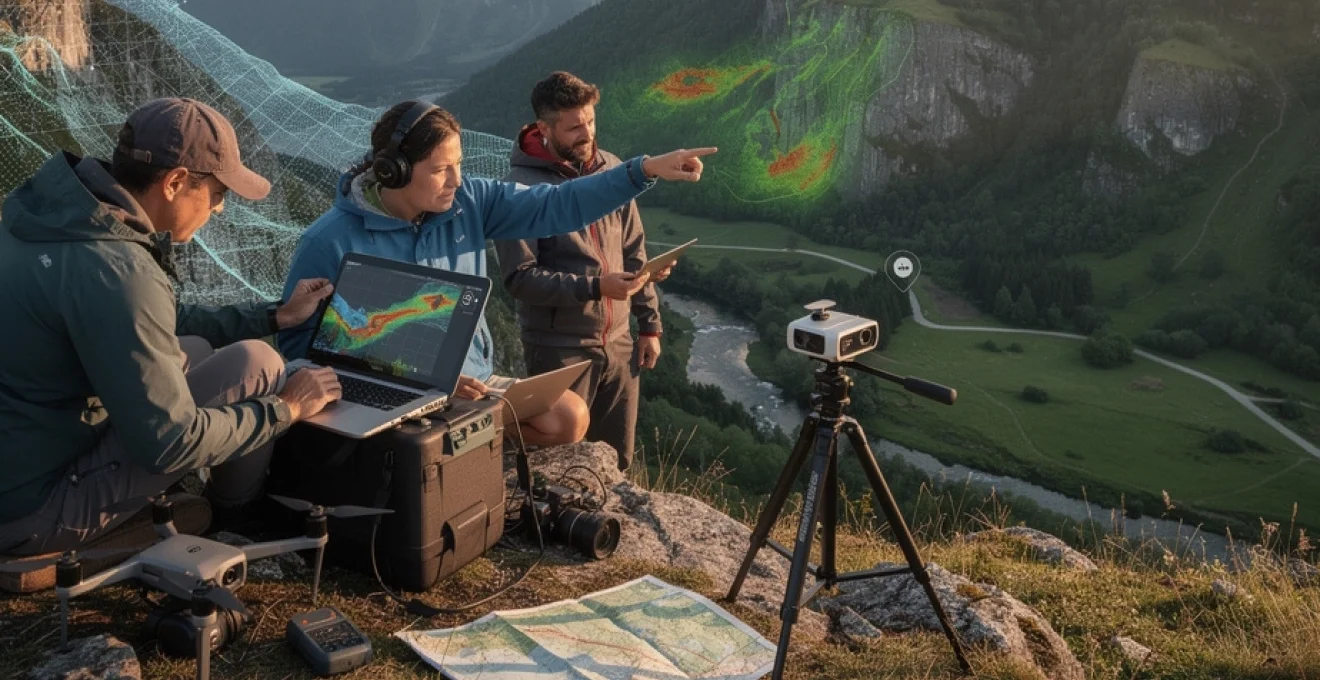
Remote cartographic analysis using digital terrain mapping technologies
Digital terrain mapping represents the cornerstone of modern exploration, providing unprecedented access to geographical data that was previously available only to military and scientific institutions. Advanced mapping technologies enable researchers to identify topographical features, elevation patterns, and landscape characteristics from thousands of miles away, creating detailed terrain models that reveal hidden valleys, unexplored plateaus, and remote coastal formations.
Lidar point cloud processing for identifying unexplored valleys
Light Detection and Ranging technology generates millions of data points that create three-dimensional representations of terrain with centimetre-level accuracy. This laser-based remote sensing technique penetrates forest canopies and reveals underlying topographical features that remain invisible to traditional aerial photography. LiDAR processing algorithms can identify narrow valleys, hidden ravines, and secluded basins that may harbour unique ecosystems or archaeological sites.
Professional exploration teams utilise specialised software to analyse point cloud data, filtering vegetation returns from ground surfaces to reveal the true shape of the landscape beneath. This technological approach has revolutionised the discovery of previously unknown geographical features, particularly in densely forested regions where conventional mapping methods prove inadequate.
Satellite imagery pattern recognition through NDVI analysis
Normalised Difference Vegetation Index analysis transforms standard satellite imagery into detailed vegetation health maps that reveal subtle environmental patterns across vast territories. This spectral analysis technique identifies areas of unique plant growth, seasonal vegetation changes, and ecological boundaries that often indicate the presence of unexplored natural habitats. NDVI calculations highlight regions where vegetation density, species composition, or growth patterns differ significantly from surrounding areas.
Advanced pattern recognition algorithms can detect anomalous vegetation signatures that suggest the presence of water sources, microclimatic variations, or geological features that create distinct ecological niches. These technological insights guide field researchers toward locations that demonstrate high potential for harboring undiscovered natural phenomena or pristine ecosystems.
Geological survey integration with OpenStreetMap data mining
The integration of geological survey data with crowdsourced mapping information creates comprehensive datasets that reveal gaps in human knowledge and exploration. OpenStreetMap analysis identifies regions with sparse contributor activity, limited road networks, and minimal human infrastructure, suggesting areas that remain relatively unexplored or inaccessible to casual visitors.
Cross-referencing geological formations with mapping data reveals locations where interesting rock formations, mineral deposits, or unique geological processes occur in areas with minimal human documentation. This systematic approach guides explorers toward regions that combine geological significance with limited human impact, increasing the likelihood of discovering pristine natural environments.
Topographical anomaly detection using machine learning algorithms
Machine learning applications in topographical analysis identify landscape features that deviate from expected geological patterns, potentially indicating the presence of unique formations or unexplored territories. Algorithmic pattern detection processes vast datasets of elevation models, identifying statistical anomalies that warrant further investigation through field research.
Neural network models trained on known geographical features can predict the likelihood of discovering interesting locations based on topographical characteristics, elevation profiles, and surrounding landscape features. This predictive approach enables researchers to prioritise exploration targets based on quantified probability assessments rather than intuitive speculation.
Advanced geocaching intelligence and location scouting methodologies
Contemporary location discovery extends beyond traditional geographical analysis to encompass digital intelligence gathering techniques that extract valuable insights from online
intelligence, community platforms, and historical datasets. Instead of treating geocaching as a casual hobby, professional scouts use it as a crowdsourced sensor network, revealing how people interact with landscapes that rarely appear in conventional guides.
Social media geotag analysis through instagram and flickr APIs
Social media platforms generate vast quantities of geotagged content that can be analysed to locate emerging points of interest before they become mainstream. By querying Instagram and Flickr APIs, researchers can map photo density, temporal posting patterns, and hashtag usage across remote regions. Areas with intermittent yet consistent geotag activity, especially where formal mapping is sparse, often indicate under-documented viewpoints, trails, or natural features known primarily to locals.
To move beyond simple visual browsing, analysts employ clustering algorithms to group images by location and subject matter. For instance, repeated references to waterfalls or canyon formations in a low-traffic area may signal a potential hidden gem worth further investigation. You can think of this process as a dynamic heatmap of curiosity: rather than following popularity, you track subtle, recurring signals that point to authentic, off-the-beaten-path locations.
Local forum mining and reddit community intelligence gathering
While social media posts provide a visual snapshot, discussion forums and Reddit communities supply context-rich narratives about remote places. Mining location-specific subreddits, regional outdoor groups, and hobbyist forums allows you to extract qualitative intelligence about hiking routes, abandoned infrastructure, lesser-known passes, and seasonal access conditions. Users often share detailed trip reports, GPS tracks, and candid assessments that never make it into commercial guidebooks.
Systematic scraping and text analysis can reveal recurring place names, colloquial toponyms, and references to “secret spots” that align with areas of low formal documentation. You might, for example, notice several independent comments about an unnamed ridge offering panoramic views or an unofficial trail connecting two valleys. By cross-referencing these accounts with digital terrain models and satellite imagery, explorers can validate which of these anecdotes correspond to genuinely unexplored terrain rather than simply alternative access points to well-known attractions.
Historical archive research via ordnance survey digital collections
Historical cartography remains an invaluable resource for discovering lost routes and forgotten settlements. Digital collections from national mapping agencies such as Ordnance Survey provide high-resolution scans of historical maps that can be compared with current datasets. Discrepancies between past and present mapping—such as vanished footpaths, relocated waterways, or abandoned industrial sites—often highlight areas where the landscape has changed faster than public awareness.
Researchers overlay historical sheets onto modern GIS layers to identify orphaned infrastructure: bridges without roads, tracks that fade into forest cover, or hamlets that no longer appear in contemporary databases. These ghost features can indicate rewilded landscapes, sealed quarries now filled with clear water, or terraces reclaimed by woodland. By combining archive research with field reconnaissance, you can reconstruct historical patterns of movement and occupation, revealing new routes into areas that have effectively fallen off the modern map.
Crowdsourced location verification using inaturalist data
Biodiversity platforms such as iNaturalist function as globally distributed observation networks, with users uploading georeferenced records of fauna and flora. Analysing these datasets reveals not only species distributions but also the spatial footprint of human presence in remote areas. Clusters of high-value observations in regions with limited infrastructure suggest that naturalists, rather than tourists, are accessing these landscapes, often via informal or difficult routes.
By filtering for rare or habitat-specific species, you can identify microhabitats and pristine ecological niches that warrant careful, low-impact exploration. Crowdsourced records also play a critical role in verification: when digital terrain analysis suggests a potential hidden valley, a handful of biodiversity observations from the same coordinates can confirm that the location is both accessible and ecologically significant. In practice, this creates a feedback loop where scientific curiosity and exploratory travel reinforce each other, while still respecting conservation priorities.
Microclimatic research for pristine ecosystem discovery
Locating truly untouched environments often depends on understanding how small-scale climate patterns shape local ecosystems. Microclimatic research focuses on variations in temperature, humidity, wind, and solar exposure over short distances—differences that can make one valley floor a lush refuge while a neighbouring ridge remains barren. Identifying these subtle gradients helps you pinpoint refugia: places where rare species persist, glaciers retreat more slowly, or ancient forests survive in sheltered hollows.
Researchers combine fine-resolution climate models with high-precision elevation data to map potential microrefugia across mountain ranges and coastal zones. For example, north-facing cirques with persistent snow cover and shaded ravines with high moisture retention are prime candidates for harbouring sensitive mosses, lichens, or endemic plant communities. Field teams then deploy inexpensive data loggers to validate conditions over time, building a detailed profile of thermal and hydrological regimes before inviting any form of responsible visitation. In effect, microclimate analysis acts as a magnifying glass, revealing hidden layers of environmental diversity within landscapes that otherwise appear uniform.
Cultural anthropology fieldwork in isolated communities
Discovering new locations off the beaten path is not solely a geographical exercise; it is equally a cultural undertaking. Isolated communities often preserve navigation knowledge, place names, and seasonal routes that remain absent from official maps. Engaging with these communities through rigorous anthropological fieldwork allows explorers to locate and understand culturally significant spaces without imposing external narratives or extractive tourism models.
Ethnographic documentation techniques for remote settlements
Ethnographic documentation in remote settlements prioritises long-term immersion, participant observation, and semi-structured interviews. Rather than arriving with a pre-defined checklist, researchers work alongside residents in everyday activities—herding, fishing, foraging, or seasonal migration. During these interactions, informal conversations reveal how local people perceive their landscape: which valleys are sacred, which passes are dangerous, and which river bends hold historical or spiritual meaning.
Field notes, audio recordings, and photographic documentation are collected under explicit consent, with clear agreements on how the material will be stored and shared. This process is less about “discovering” places in a colonial sense and more about co-documenting existing knowledge in a respectful, collaborative manner. For those seeking authentic off-the-beaten-path experiences, such documentation offers guidance on where you should not go as much as where you might be welcome, ensuring that exploration supports cultural continuity rather than undermining it.
Indigenous knowledge systems for traditional navigation routes
Indigenous navigation systems predate modern cartography by centuries, relying on a sophisticated understanding of stars, currents, seasonal winds, animal behaviour, and landscape cues. In many regions, these systems still guide hunting expeditions, trade routes, and ceremonial journeys that cross terrain absent from mainstream hiking maps. Collaborating with Indigenous knowledge holders under ethically sound frameworks can reveal networks of trails and waypoints that tie together seemingly isolated valleys and coastlines.
These traditional routes often optimise for safety, resource availability, and spiritual significance rather than speed or directness. For instance, a path may detour to avoid avalanche-prone slopes or to pass through particular groves used for medicinal plant gathering. When such knowledge is shared, it must be done on terms defined by the community: some routes may be suitable for limited eco-tourism, while others remain strictly restricted. As explorers, we have a responsibility to treat Indigenous navigation not as a free dataset but as an intellectual and cultural property that demands reciprocity and protection.
Linguistic mapping of dialectal variations in highland regions
Linguistic variation provides another subtle but powerful lens for identifying hidden cultural landscapes. In many highland regions, dialect boundaries align with historical patterns of settlement, trade, and isolation. By mapping where particular phonetic shifts, vocabulary items, or place-name structures occur, linguists can infer historic connections between valleys, passes, and river basins that are not obvious from topography alone.
For example, clusters of unique toponyms for water sources or grazing grounds may indicate traditional transhumance routes, even if the physical paths are now overgrown. Overlaying dialect maps with elevation data, historical routes, and modern infrastructure can highlight culturally coherent micro-regions that remain poorly documented in tourist literature. For travellers committed to responsible, off-the-beaten-path exploration, understanding these linguistic patterns helps ensure that new routes respect existing community boundaries and cultural identities, rather than inadvertently crossing sensitive frontiers.
Risk assessment protocols for uncharted territory exploration
Venturing into partially mapped landscapes demands a robust, evidence-based approach to risk assessment. While the notion of “uncharted territory” may sound romantic, it often conceals real hazards: unstable geology, flash-flood zones, glacial crevasses, or complex political boundaries. Effective risk management integrates geospatial analysis, environmental forecasting, and social intelligence into a single decision-making framework.
Before any field deployment, exploration teams conduct multi-layered hazard mapping using digital elevation models, historical landslide records, floodplain maps, and meteorological data. Probabilistic models estimate the likelihood of rockfall, river surges, or sudden weather shifts along proposed routes. At the same time, socio-political assessments consider land ownership, local conflicts, protected area regulations, and Indigenous rights frameworks. The result is a graded risk matrix that informs route selection, equipment load-outs, and emergency evacuation plans.
On the ground, protocols emphasise redundancy and communication. Satellite messengers, offline mapping tools, and pre-agreed check-in schedules ensure that support teams can track progress and respond quickly if conditions deteriorate. Field personnel undergo training in wilderness first aid, navigation under low visibility, and conflict-sensitive engagement with local stakeholders. By treating risk assessment as a continuous, adaptive process rather than a one-time checklist, explorers can push into less-documented regions while maintaining a high margin of safety for both themselves and the communities they encounter.
Digital documentation and preservation standards for new discoveries
Once new locations and routes are identified, the question becomes: how should they be recorded and, if at all, shared? Digital documentation serves both scientific and ethical purposes, creating verifiable records of landscapes and cultural sites while minimising physical disturbance. However, irresponsible disclosure can rapidly transform a fragile area into an overrun hotspot, undermining the very qualities that made it valuable.
Best practice begins with structured data capture. High-resolution imagery, GPS tracks, 3D photogrammetry models, and biodiversity observations are stored in well-documented formats with clear metadata: time, weather conditions, team members present, consent status from local communities, and access constraints. Wherever possible, sensitive coordinates—such as nesting sites, sacred locations, or habitats of endangered species—are geoblurred or generalised in any public release, with full datasets kept in restricted archives accessible only to vetted researchers or management authorities.
Adhering to international standards, such as the Dublin Core metadata schema or FAIR (Findable, Accessible, Interoperable, Reusable) data principles, ensures that digital records remain usable decades into the future. Simultaneously, communities involved in the discovery process should retain co-ownership or full control over how their knowledge is represented online. In practice, this may mean that some of the most remarkable off-the-beaten-path locations are documented primarily for conservation and cultural continuity rather than for tourism promotion. By accepting this balance, we help ensure that discovering new locations off the beaten path contributes to long-term protection and understanding, rather than short-term exploitation.