Argentina’s Patagonian wilderness represents one of Earth’s most extraordinary natural laboratories, where ancient glacial forces have sculpted a landscape of unparalleled beauty and scientific significance. Stretching across the southern reaches of South America, this vast region encompasses everything from towering granite spires that pierce the sky to massive ice fields that continue their millennia-old dance of advance and retreat. The interplay between geological forces, climatic conditions, and biological adaptations has created an ecosystem so unique that it draws researchers, adventurers, and nature enthusiasts from every corner of the globe.
What makes Argentine Patagonia particularly fascinating is its role as a living testament to the planet’s climatic history. The region’s glacial systems serve as natural archives, preserving records of atmospheric conditions spanning thousands of years. Meanwhile, its diverse ecosystems—from windswept steppes to ancient forests—showcase remarkable examples of evolutionary adaptation in extreme environments. This convergence of geological wonder and biological diversity creates opportunities for understanding both our planet’s past and the challenges facing its future.
Glacial landscapes and ice field formations in patagonian argentina
The glacial landscapes of Argentine Patagonia constitute one of the world’s most dynamic and scientifically valuable ice environments outside the polar regions. The Southern Patagonian Ice Field, known locally as Campo de Hielo Patagónico Sur, spans approximately 13,000 square kilometres and feeds dozens of outlet glaciers that flow both eastward toward the Atlantic and westward toward the Pacific Ocean. This massive ice sheet represents the third-largest freshwater reserve on the planet, containing enough water to raise global sea levels by several centimetres if completely melted.
The formation of these ice fields dates back approximately 2.6 million years, during the onset of the Quaternary glaciation period. However, the current configuration took shape around 18,000 years ago during the Last Glacial Maximum, when ice extended far beyond its present boundaries. The retreat and advance patterns of these glaciers provide crucial data for understanding climate change impacts on polar and sub-polar regions. Unlike many glacier systems worldwide that are experiencing rapid retreat, several Patagonian glaciers exhibit complex behaviours, with some advancing while others retreat, creating a natural laboratory for glaciological research.
The dynamic nature of Patagonian glaciers offers unprecedented insights into ice sheet behaviour under changing climatic conditions, making this region essential for understanding global ice dynamics and sea-level rise projections.
Perito moreno glacier dynamics and calving phenomena
Perito Moreno Glacier stands as perhaps the most famous and scientifically significant glacier in the Southern Hemisphere, renowned for its spectacular calving events and unusual stability in an era of widespread glacial retreat. This 30-kilometre-long ice river advances approximately two metres per day at its terminus, creating a dynamic equilibrium where ice accumulation in the névé region balances ice loss through calving and melting. The glacier’s face rises 60 metres above Lago Argentino’s surface, with an additional 120 metres extending below the waterline.
The calving phenomena at Perito Moreno occur due to complex interactions between ice dynamics, water temperature, and structural stresses within the glacier. As the glacier advances, it periodically dams the Brazo Rico arm of Lago Argentino, creating water level differences of up to 30 metres. The resulting hydrostatic pressure eventually causes the ice dam to rupture in spectacular fashion, with massive ice blocks thundering into the lake. These rupture events, occurring roughly every four to five years, provide valuable data about ice mechanics and the relationship between glacial dynamics and lacustrine systems.
Southern patagonian ice field retreat patterns
Analysis of the Southern Patagonian Ice Field reveals complex retreat patterns that vary significantly among individual glacier systems. Over the past century, the ice field has lost approximately 500 cubic kilometres of ice, contributing measurably to global sea-level rise. However, this retreat is not uniform—eastern glaciers flowing into Argentine lakes show different behaviours compared to western glaciers terminating in Chilean fjords. The eastern glaciers, including Upsala and Viedma, have experienced rapid retreat rates of up to 1.5 kilometres per decade, while some western glaciers maintain relatively stable positions.
These contrasting retreat patterns are influenced by factors such as precipitation gradients across the Andes, differences in bedrock topography, and the depth and temperature of proglacial lakes and fjords. Researchers have noted that glaciers terminating in deep water bodies tend to calve more frequently, accelerating ice loss compared to land-terminating glaciers. For travellers exploring Patagonia in Argentina, this means that each valley tells a slightly different climate story: a rapidly shrinking ice tongue in one basin may sit just a day’s journey away from a relatively stable glacier in another.
From a climate science perspective, the Southern Patagonian Ice Field functions like a giant barometer, responding sensitively to changes in temperature and precipitation. Satellite imagery combined with on-the-ground GPS measurements allows glaciologists to monitor these shifts in near real time, improving models of future sea-level rise. As you stand at a viewpoint above one of these outlet glaciers, you are not only admiring a dramatic landscape—you are also looking at one of the world’s most important indicators of global climatic change.
Glacial lake formation at lago argentino
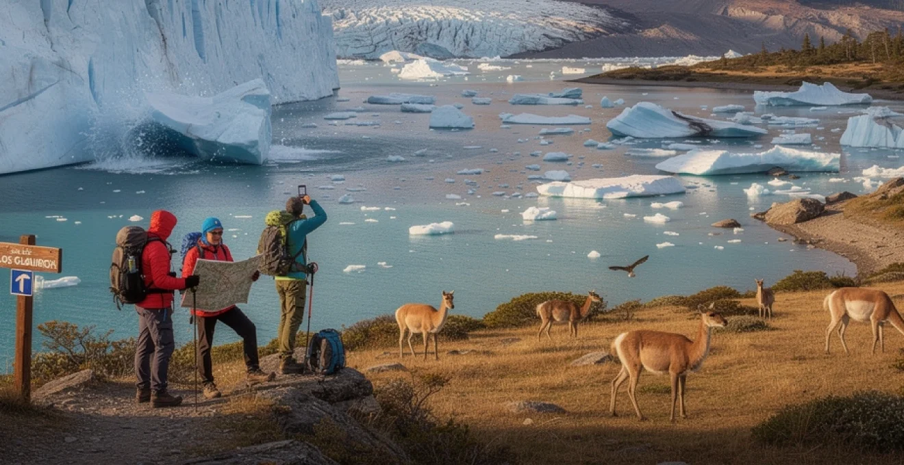
Lago Argentino, the largest freshwater lake in Argentina, owes its existence to the carving power of ancient ice flowing eastward from the Southern Patagonian Ice Field. During the Last Glacial Maximum, massive valley glaciers scoured deep troughs into the underlying sedimentary and crystalline bedrock, much like a slow-moving bulldozer shaping a new basin. When the climate warmed and the ice retreated, these over-deepened valleys filled with meltwater, forming the intricate system of arms and channels that now make up Lago Argentino.
The lake’s characteristic turquoise colour results from suspended glacial flour—fine rock particles ground down by the ice and carried into the lake by meltwater streams. These microscopic sediments scatter sunlight, creating the milky blue tones that have become synonymous with Patagonia’s natural wonders. For visitors, boat excursions across Lago Argentino provide a front-row seat to observe this process in action, as sediment-laden streams pour into the lake at glacier fronts and delta systems.
From a hydrological perspective, Lago Argentino acts as a crucial buffer between the ice field and the Santa Cruz River, regulating water discharge and influencing regional ecosystems downstream. Seasonal variations in meltwater input can raise or lower lake levels by several metres, subtly reshaping shorelines, wetlands, and submerged habitats. Understanding these glacial lake dynamics helps scientists assess flood risks, model sediment transport, and predict how the landscape will continue to evolve as the climate warms.
For those planning to explore Patagonia in Argentina, timing a visit to coincide with late spring or summer offers the best combination of navigable waters and vibrant colours. However, even in winter, the quieter atmosphere and low-angled light can make the lake’s surface look like polished steel, emphasizing the stark relationship between water, rock, and ice that defines this part of the world.
Upsala glacier fragmentation and iceberg production
Upsala Glacier, one of the most extensive outlet glaciers of the Southern Patagonian Ice Field, has become a textbook example of rapid glacial retreat and fragmentation. Over recent decades, remote sensing studies have documented the loss of tens of square kilometres of ice, with the glacier front pulling back from its former position and leaving behind a growing expanse of proglacial water. This retreat is closely linked to the deepening and widening of its associated lake arm, which promotes enhanced calving and the formation of massive icebergs.
Iceberg production at Upsala is driven by both mechanical and thermal processes. As the glacier flows into deep water, buoyant forces act on the front, creating fractures that eventually detach large blocks of ice. At the same time, relatively warmer lake water melts the submerged ice face from below, undermining its structural integrity. The result is a flotilla of tabular and pinnacled icebergs that can drift for kilometres along the lake, some the size of multi-storey buildings.
For travellers, navigating the Upsala arm of Lago Argentino by boat is often compared to entering an open-air ice sculpture gallery. Each iceberg carries a unique pattern of fractures, air bubbles, and blue-toned crevasses, telling its own story of stress and transformation. Yet these stunning sights also serve as visual reminders of how swiftly parts of the Patagonian ice field are responding to rising temperatures. What might this seascape look like in another 50 years if current trends continue?
Glaciologists studying Upsala use the glacier’s fragmentation as a natural laboratory to refine models of calving dynamics, which are notoriously difficult to capture with precision. Lessons learned here can be applied to understand the behaviour of Greenland and Antarctic outlet glaciers, where calving also plays a major role in ice loss. In this sense, Upsala Glacier links the remote landscapes of Patagonia in Argentina to global discussions about sea-level rise and climate resilience.
Andean peak systems and alpine ecosystems of santa cruz province
Moving from the ice fields to the sky-piercing summits, the Andean peak systems of Santa Cruz Province form one of the most iconic skylines on Earth. Here, sculpted granite towers, snow-clad ridges, and serrated aretes rise abruptly from glacial valleys, creating a dramatic vertical world that attracts climbers, trekkers, and geologists alike. The El Chaltén region, in particular, showcases a remarkable interplay between tectonic uplift, magmatic intrusions, and erosive forces, all set against a backdrop of changing weather and fragile alpine ecosystems.
These mountains are not just scenic landmarks; they are living laboratories where you can directly observe processes that usually unfold over millions of years. Deep magmas that once crystallized kilometres below the surface are now exposed as gleaming rock walls, while cirques and hanging valleys testify to the sculpting power of ice. As we explore these Andean peaks, we also encounter a mosaic of specialized plant and animal communities that have adapted to life in thin air, intense winds, and extreme temperature swings.
Cerro fitz roy granite tower geological composition
Cerro Fitz Roy, or Chaltén in the language of the Tehuelche people, is a classic example of a granitic batholith exposed by millions of years of erosion. The mountain’s sheer walls and jagged ridges are primarily composed of coarse-grained granite and granodiorite, intrusive igneous rocks formed from slowly cooling magma deep within the Earth’s crust. Over time, the overlying sedimentary layers were stripped away by glacial and fluvial erosion, revealing the resistant crystalline core that now dominates the skyline.
The vertical cracks and joint systems that climbers use as handholds are actually the result of cooling and tectonic stresses acting on the solidifying magma body. As the rock contracted and uplifted, it fractured along preferred orientations, creating natural planes of weakness. Glacial ice later exploited these fractures, plucking and grinding away blocks of rock and sculpting the sharp ridges we see today. You can think of Fitz Roy as a giant stone sculpture slowly revealed by nature’s chisel of ice and water.
From a geological standpoint, the pale colours and coarse crystals visible on Fitz Roy’s faces indicate a slow cooling rate at depth, which allowed minerals like quartz, feldspar, and mica to grow large. These compositional details help geologists reconstruct the magmatic history of the Patagonian Andes and understand how subduction processes along the Pacific margin generated such extensive plutonic complexes. For hikers and photographers, this same mineralogy translates into cliffs that glow warm orange at sunrise, making Cerro Fitz Roy one of the most photographed peaks in Patagonia in Argentina.
Detailed petrological studies of rock samples from the Fitz Roy massif also reveal a complex story of multiple magma pulses and subsequent metamorphism. Small variations in mineral content across the massif point to evolving magma chemistry over time, while contact zones between granite and surrounding rocks show evidence of intense heat and deformation. In this way, a single mountain encapsulates the broader tectonic narrative of the southern Andes.
Cerro torre weather pattern complexities
Just west of Fitz Roy, Cerro Torre is renowned not only for its slender, ice-plastered spire but also for its notoriously harsh and unpredictable weather. Sitting closer to the Pacific moisture source and directly in the path of the roaring westerlies, Cerro Torre experiences some of the most extreme wind and cloud conditions in Patagonia. Climbers often describe the mountain as being wrapped in its own private weather system, with lenticular clouds forming and dissipating around the summit like a permanent crown.
The complex weather patterns here arise from the steep orographic barrier formed by the Patagonian Andes. Moist air masses from the Pacific are forced to rise rapidly over the mountains, cooling and condensing into dense cloud banks that can cloak the peaks for days. As the air descends on the Argentine side, it warms and dries, generating strong föhn winds on the eastern slopes. This contrast means you might experience relatively clear skies in El Chaltén while Cerro Torre itself remains shrouded in storms just a few kilometres away.
For mountaineers, these conditions translate into narrow and unpredictable climbing windows. Storm systems can intensify in a matter of hours, bringing hurricane-force gusts, rime ice accumulation, and white-out visibility. Planning a safe ascent requires careful monitoring of local forecasts, satellite imagery, and barometric trends, often over several days. For most visitors, however, even a distant view of Cerro Torre emerging from the clouds is a reminder of nature’s power and the challenges of high-altitude exploration in Patagonia in Argentina.
Meteorologists are increasingly using Cerro Torre and its neighbouring peaks as case studies to refine models of mountain weather systems in mid-latitude regions. High-resolution simulations help explain how small-scale topography can amplify wind speeds and generate complex vortex patterns around individual summits. Understanding these processes does not just aid climbers; it also improves regional forecasts for aviation, trekking, and conservation work across Santa Cruz Province.
Alpine flora adaptations in lenga forest transitions
As you ascend from the valley floors around El Chaltén toward the high cirques and passes, you pass through a distinct ecological gradient dominated by Nothofagus forests. The lenga beech (Nothofagus pumilio) is particularly emblematic of this transition zone, forming dense stands at mid-elevations before giving way to low, wind-pruned shrubs and alpine meadows. These forests mark the boundary between the more temperate lower slopes and the harsh, open environments of the alpine zone.
Lenga trees exhibit several remarkable adaptations that allow them to thrive in the windy, snowy conditions of Patagonian mountain slopes. Their flexible trunks and branches bend rather than break under heavy snow loads, while their shallow but wide-spreading root systems anchor them in thin, rocky soils. The trees’ deciduous habit—shedding leaves in winter—reduces water loss and damage from ice accumulation. Walking through a lenga forest in autumn, you may notice how their leaves turn brilliant shades of red and gold, creating one of the most colourful displays in Patagonia in Argentina.
Above the treeline, low-growing cushion plants, lichens, and hardy grasses dominate. These alpine flora species hug the ground to avoid desiccating winds, and many possess waxy leaf surfaces or dense hairs that reduce water loss. Some cushion plants function almost like natural greenhouses, trapping a thin layer of warmer air close to the soil surface and protecting delicate buds from frost. This micro-scale climate engineering is a clever analogue to how we might design energy-efficient buildings in windy, cold environments.
Ecologists studying these transitional zones are particularly interested in how climate change may shift the elevation ranges of key species. As temperatures rise, lenga forests could gradually migrate upslope, compressing the available habitat for specialized alpine plants. By monitoring permanent plots across this gradient, researchers can detect early signs of ecosystem change and advise park managers on how to protect biodiversity in Los Glaciares National Park and surrounding areas.
High-altitude wildlife corridors and species migration
Mountain landscapes in Patagonia in Argentina might appear rugged and fragmented, but for wildlife they function as critical corridors connecting different habitats across elevation and latitude. Guanacos, foxes, and pumas use saddles and valley systems to move between summer and winter ranges, tracking the availability of forage and prey. Bird species such as the Andean condor rely on strong updrafts along cliffs to travel long distances in search of carrion, effectively using the mountain range as an aerial highway.
At higher elevations, these wildlife corridors become particularly important for species that depend on both alpine and forest environments during different life stages. The elusive huemul deer, for example, may browse in sheltered forest patches during severe weather but move into open alpine meadows when conditions are milder and fresh vegetation emerges. Maintaining connectivity between these habitats is essential for the long-term survival of such endangered species.
Climate change and human infrastructure can disrupt these natural movement patterns. Roads, fences, and unmanaged tourism infrastructure may fragment habitats and create barriers that animals struggle to cross. Conservation planners in Santa Cruz Province are increasingly using GPS collar data, camera traps, and landscape connectivity models to identify key wildlife corridors and prioritize them for protection. Have you ever considered that a simple mountain pass you cross on a hike might be a lifeline route for animals moving across entire mountain ranges?
By integrating wildlife corridor mapping into regional land-use planning, authorities can design trekking routes, viewing platforms, and even grazing areas in ways that minimize disruption. For visitors, this means that following designated trails and respecting seasonal closures is not just a safety measure—it is a way of actively supporting the movement and survival of Patagonia’s high-altitude fauna.
Steppe biodiversity hotspots and endemic species distribution
Beyond the dramatic ice fields and jagged peaks, much of Patagonia in Argentina is characterized by vast, open steppe—a landscape that might seem empty at first glance but actually harbours surprising biodiversity. This semi-arid environment, shaped by persistent westerly winds and low precipitation, supports a unique assemblage of grasses, shrubs, and hardy animals that have adapted to extremes of temperature and limited water. The Patagonian steppe stretches across large parts of Santa Cruz and neighbouring provinces, forming a crucial ecological matrix between mountains, rivers, and coastal zones.
Within this steppe, biodiversity hotspots emerge around water sources, rocky outcrops, and ecotones where grasslands meet shrublands or wetlands. Here, plant diversity increases, providing food and shelter for insects, small mammals, and birds. Endemic species such as the Patagonian mara (a large rodent resembling a small antelope) and various ground-dwelling birds rely on these pockets of richer habitat. Predators like the puma and culpeo fox, in turn, depend on healthy populations of guanacos, hares, and smaller prey scattered across the steppe.
Botanically, the steppe is dominated by tussock grasses and cushion-forming shrubs such as Mulinum spinosum, whose spiny mounds offer shelter from wind and herbivores. Many of these plants possess deep root systems that tap into scarce groundwater and help stabilize soils, limiting erosion. By storing carbon in both their roots and above-ground biomass, steppe ecosystems also contribute to regional carbon budgets—an important, if often overlooked, function in discussions of climate mitigation.
Human land use, particularly extensive sheep grazing introduced in the late 19th and early 20th centuries, has significantly altered steppe dynamics. Overgrazing can degrade plant communities, reduce native species cover, and increase soil compaction, making it harder for sensitive plants to regenerate. Conservation initiatives in Patagonia in Argentina now focus on promoting sustainable grazing practices, establishing protected areas, and restoring degraded patches through native plant reintroduction. For travellers, visiting private estancias that embrace regenerative agriculture offers a chance to see how traditional livelihoods and biodiversity conservation can coexist.
Los glaciares national park conservation frameworks
Los Glaciares National Park, a UNESCO World Heritage Site since 1981, serves as a cornerstone of conservation in Patagonia in Argentina. Covering over 7,000 square kilometres, the park protects a remarkable cross-section of ecosystems—from lowland steppes and Andean forests to high alpine zones and the eastern margin of the Southern Patagonian Ice Field. Its conservation frameworks are designed not only to preserve scenic beauty but also to safeguard water resources, endemic species, and cultural heritage connected to indigenous and settler histories.
The park’s management plan is built around a zoning system that differentiates between intensive-use areas, such as viewpoints and short trails, and strict conservation zones where human access is highly restricted. This approach helps concentrate visitor impacts in robust, well-serviced locations while leaving sensitive habitats and wildlife refuges undisturbed. For instance, boardwalks and designated viewing platforms near Perito Moreno Glacier protect fragile shorelines and vegetation from trampling, even as visitor numbers rise.
Scientific research plays a central role in these conservation frameworks. Long-term monitoring programs track glacier front positions, lake levels, vegetation changes, and wildlife populations, providing the data needed to adapt management strategies over time. In a sense, the park operates like a large-scale experiment in how to balance tourism, conservation, and local livelihoods in a changing climate. Could this model offer lessons for other mountain regions around the world grappling with similar challenges?
Community involvement is another key pillar. Local residents, tour operators, and indigenous groups are increasingly engaged in decision-making processes, whether through consultative councils or co-managed projects. Environmental education initiatives in nearby towns like El Calafate and El Chaltén aim to foster a stewardship ethic among both locals and visitors. When you attend a ranger talk or follow Leave No Trace principles on the trail, you are participating in this broader conservation culture.
Trekking circuit infrastructure and wilderness navigation systems
For many visitors, the most direct way to experience the natural wonders of Patagonia in Argentina is on foot. Over the past decades, a network of trekking circuits, refuges, and waymarked trails has developed across the region, especially around Los Glaciares National Park and the cross-border routes linking Argentina and Chile. This infrastructure is carefully designed to provide access while minimizing environmental impact, guiding hikers along durable paths and away from erosion-prone slopes or sensitive wildlife habitats.
Modern wilderness navigation in Patagonia combines traditional skills—map reading, compass use, and terrain assessment—with digital tools such as GPS devices and satellite-based weather updates. Given how fast conditions can change in the Andes, being able to interpret both the sky and your map remains essential. Even on well-trodden routes, strong winds, sudden snowfall, or dense cloud cover can transform an easy day hike into a serious challenge, underscoring the need for robust trekking systems and informed planning.
Torres del paine circuit cross-border access points
Although Torres del Paine National Park lies across the border in Chile, its trekking circuits are closely connected to the Argentine side of Patagonia through a series of access points and logistical hubs. Many travellers base themselves in El Calafate or El Chaltén before crossing into Chile to undertake the famous W Trek or O Circuit, effectively experiencing the broader Patagonian ecosystem as a single, transboundary destination. This cross-border flow highlights how ecological and cultural regions often transcend political boundaries.
Key access routes include road connections from El Calafate to the Chilean town of Puerto Natales, as well as less-travelled passes used by specialized trekking and horseback expeditions. At these crossing points, customs and immigration controls are combined with biosecurity checks to prevent the introduction of invasive species, such as non-native seeds or pathogens, into fragile ecosystems. Simple actions—like cleaning your boots and gear before crossing—become part of a collective effort to protect both sides of the border.
From a conservation planning perspective, these shared trekking circuits demand coordination between Argentine and Chilean park authorities. Joint initiatives address issues such as search-and-rescue protocols, wildfire prevention, and visitor education campaigns. For trekkers, this means that safety standards and environmental guidelines tend to be broadly aligned, even when you are technically moving between different national jurisdictions. It is an evolving model of international cooperation rooted in a shared appreciation for Patagonia’s unique landscapes.
Logistically, understanding these cross-border dynamics helps you plan realistic itineraries. Travel times between hubs, availability of transport, and seasonal operating schedules for mountain passes can all affect whether a combined Argentina–Chile trekking trip is feasible within your timeframe. Checking updated information from both countries’ park services before you set out is as important as packing the right boots.
El chaltén base camp logistics and weather monitoring
Often called the trekking capital of Argentina, El Chaltén functions as a natural base camp for exploring the Fitz Roy and Cerro Torre massifs. Despite its small size, the town offers a well-developed support network for hikers, including accommodation, gear rental, guiding services, and information centres. Trailheads for classic routes such as Laguna de los Tres and Laguna Torre begin right on the edge of town, allowing you to transition from breakfast at a café to high mountain vistas within a few hours.
Effective logistics in El Chaltén hinge on two main factors: weather monitoring and route selection. Local forecasting services, ranger stations, and even hostel notice boards provide up-to-date information on wind speeds, precipitation, and visibility. Given Patagonia’s reputation for four seasons in a single day, experienced trekkers often build flexibility into their plans, keeping one or two “buffer days” to wait out storms or reschedule longer hikes. Treating the forecast as a dynamic tool rather than a fixed promise can make the difference between a safe, enjoyable outing and an uncomfortable ordeal.
On the navigation side, most popular trails are well signposted and maintained, reducing the risk of becoming lost in good conditions. However, carrying a topographic map or offline GPS app remains wise, especially if you intend to explore lesser-known routes or shoulder-season conditions with snow cover. Local guides can also provide invaluable context, from pointing out subtle weather signs to sharing stories about past expeditions and regional geology. Choosing to hire a guide is not just about safety; it is also a way to deepen your understanding of Patagonia in Argentina.
Infrastructure improvements in recent years—such as strategically placed campsites, composting toilets, and reinforced trail sections—have further enhanced the sustainability of trekking around El Chaltén. By concentrating overnight stays and high-traffic zones, park authorities and local businesses can better manage waste, water use, and vegetation recovery, ensuring that the growing popularity of the area does not come at the expense of its ecological integrity.
Backcountry permit systems and environmental impact protocols
As interest in wilderness experiences grows worldwide, backcountry areas of Patagonia in Argentina have implemented permit systems and environmental protocols to protect fragile landscapes. In Los Glaciares National Park and other protected zones, certain remote routes, climbing objectives, or multi-day expeditions require advance registration with park authorities. These permits help managers track visitor numbers, plan for search-and-rescue capacity, and identify areas where impacts may be increasing.
Environmental impact protocols typically include guidelines on campsite selection, waste disposal, and interactions with wildlife. Travellers are encouraged—or in some cases required—to follow Leave No Trace principles: camping on durable surfaces, packing out all non-biodegradable waste, and avoiding the collection of firewood in sensitive areas. Some zones restrict open fires altogether, relying instead on portable stoves to reduce the risk of wildfires in the often dry, windy conditions of the Patagonian steppe and forests.
In practical terms, this means that planning a backcountry trip involves more than just checking your gear list. You will need to research current permit requirements, seasonal closures, and route-specific regulations, often by consulting official park websites or ranger stations. While these steps may seem bureaucratic at first, they function like a safety net for both you and the environment, ensuring that remote valleys remain pristine and that rescue teams know where to look if something goes wrong.
Looking ahead, digital permitting platforms and real-time visitor data are likely to play a larger role in managing wilderness access across Patagonia in Argentina. These tools can help distribute use more evenly, prevent overcrowding at popular sites, and rapidly communicate hazards such as flooding or fire. For responsible travellers, embracing these systems is part of a broader commitment to experiencing Patagonia’s natural wonders in a way that ensures they remain intact for generations to come.