Nestled between dramatic mountain peaks and crystal-clear waters, Montenegro emerges as the Adriatic’s most visually stunning destination, offering an extraordinary concentration of natural beauty within its compact borders. This small Balkan nation, spanning merely 13,812 square kilometres, delivers an unparalleled diversity of landscapes that would challenge countries ten times its size. From the fjord-like Bay of Kotor to the pristine glacial lakes of Durmitor National Park, Montenegro presents photographers and travellers with an almost overwhelming array of scenic opportunities. The country’s unique position at the crossroads of Mediterranean and Alpine climates creates a remarkable tapestry of ecosystems, making it a genuine paradise for those seeking authentic natural experiences along Europe’s most captivating coastline.
Montenegro’s diverse topographical features and adriatic coastline geography
Montenegro’s geological foundation tells a remarkable story of tectonic forces that have sculpted one of Europe’s most diverse landscapes within an impossibly small area. The country’s terrain rises dramatically from sea level to over 2,500 metres at Bobotov Kuk peak in just 50 kilometres, creating a vertical playground that encompasses Mediterranean coastal plains, karst plateaus, and high alpine environments. This extraordinary topographical diversity results from the collision of the African and Eurasian tectonic plates, which continues to shape the region’s dramatic relief today.
Dinaric alps mountain range integration with coastal plains
The Dinaric Alps form Montenegro’s backbone, creating a spectacular transition zone where mountains plunge directly into the Adriatic Sea. This unique geological configuration produces some of Europe’s most dramatic coastal scenery, with limestone peaks rising over 1,700 metres just kilometres from pristine beaches. The mountain-to-sea elevation changes occur so rapidly that visitors can experience alpine and Mediterranean climates within a single hour’s drive, a phenomenon virtually unmatched anywhere else along the Adriatic coastline.
The integration of these mountain ranges with coastal plains creates distinctive microclimates that support an extraordinary variety of flora and fauna. Endemic species flourish in the transition zones, while the steep gradients produce numerous waterfalls and springs that feed crystal-clear rivers flowing directly into the sea. The Dinaric Alps’ limestone composition contributes to the remarkable clarity of Montenegro’s coastal waters, as the porous rock naturally filters runoff before it reaches the ocean.
Bay of kotor Fjord-Like formation and geological significance
The Bay of Kotor represents one of the Mediterranean’s most extraordinary geological formations, often mistaken for a true fjord but actually formed through tectonic subsidence and karst processes. This ria formation creates a 28-kilometre inland penetration of seawater surrounded by towering limestone cliffs that rise over 1,000 metres directly from the water’s edge. The bay’s serpentine shape and multiple inlets create constantly changing vistas that have inspired countless artists and writers throughout history.
The Bay of Kotor’s geological complexity produces water depths exceeding 60 metres in some areas, while maintaining crystal-clear visibility that allows visitors to observe marine life at remarkable depths.
The bay’s formation involved multiple geological processes over millions of years, including river erosion, tectonic subsidence, and sea-level fluctuations during ice ages. This complex history has created underwater caves, thermal springs, and unique sediment patterns that contribute to the bay’s exceptional beauty and ecological significance. The surrounding mountains create a natural amphitheatre that amplifies the bay’s visual impact while protecting it from harsh Adriatic storms.
Budva riviera limestone cliffs and mediterranean microclimate
The Budva Riviera showcases Montenegro’s most accessible Mediterranean landscapes, where dramatic limestone cliffs alternate with secluded beaches and historic coastal settlements. The region’s geology, dominated by Mesozoic limestone formations, creates the characteristic white and grey cliff faces that provide stunning contrasts against the turquoise waters. These limestone formations, carved by millennia of wave action and weather, have produced countless sea caves, natural arches, and hidden coves that make the coastline endlessly photogenic.
The microclimate along the Budva Riviera benefits from the sheltering effect of surrounding mountains
The microclimate along the Budva Riviera benefits from the sheltering effect of surrounding mountains, which block colder continental air and allow warm sea breezes to circulate freely. As a result, this stretch of coastline enjoys over 240 sunny days per year and mild winters, making it one of the most reliable year-round coastal photography locations in the Adriatic. Olive groves, citrus orchards and maquis vegetation cling to the terraced slopes above the shore, adding textural layers and seasonal colour to every frame. For photographers and coastal walkers, the interplay between vertical limestone walls, pocket-sized beaches and intensely blue water creates almost continuous “frame-worthy” compositions along this Riviera.
Skadar lake karst landscape and wetland ecosystem
Extending along the border with Albania, Skadar Lake represents one of the Adriatic region’s most impressive karst landscapes and wetland ecosystems. Formed by tectonic depression and subsequent flooding of a karst plain, the lake’s water levels can fluctuate by several metres between seasons, dramatically reshaping shorelines and reed beds. With a surface area that can reach over 500 square kilometres at high water, Skadar is the largest lake in the Balkans and a crucial freshwater reservoir for Montenegro’s coastal hinterland. Its irregular shoreline, dotted with peninsulas, islets and semi-submerged villages, offers an entirely different visual character from the stark limestone of the open coast.
Ecologically, Skadar Lake is recognised as a Ramsar site and one of Europe’s most important bird habitats, hosting more than 270 recorded species, including the rare Dalmatian pelican and pygmy cormorant. Vast carpets of water lilies, floating meadows and reed channels create a mosaic landscape that seems almost otherworldly when seen from above or from low on the water in a traditional wooden boat. Because of the lake’s karstic nature, countless springs and underwater sources feed the basin with exceptionally clear, cool water, particularly along the northern shore near Rijeka Crnojevića. For visitors, early morning and late afternoon boat trips offer ideal conditions to capture mirror-like reflections, soft mist and wildlife activity that define Skadar’s unique Adriatic wetland scenery.
UNESCO world heritage natural and cultural landmarks
Montenegro’s scenic reputation is reinforced by the presence of multiple UNESCO World Heritage sites that combine natural drama with deep cultural layers. Rather than isolating nature and history, these landscapes demonstrate how human settlement has adapted to, and often enhanced, extraordinary terrain. For travellers comparing Adriatic destinations, Montenegro stands out because so many iconic viewpoints are also gateways to living heritage. You are rarely just photographing a mountain or a bay; you are capturing centuries of trade, defence and everyday life etched into stone walls and alpine pastures.
Durmitor national park glacial cirques and tara river canyon
Durmitor National Park, inscribed on the UNESCO World Heritage List in 1980, represents Montenegro’s high-mountain heart and one of Europe’s most striking glacial landscapes. The Durmitor massif, carved by ancient ice sheets, is characterised by deep glacial cirques, sharp ridgelines and plateaus pitted with over a dozen glacial lakes known locally as gorske oči, or “mountain eyes”. The most accessible of these, Crno Jezero (Black Lake), sits in a forested basin beneath soaring limestone walls and offers perfect conditions for capturing lake reflections framed by dark conifer silhouettes. On calm days, the water’s surface behaves like a natural mirror, doubling the impact of the surrounding peaks in a single shot.
Equally dramatic is the Tara River Canyon, which forms part of the same UNESCO-listed area and is often cited as Europe’s deepest canyon, reaching depths of up to 1,300 metres. Here, turquoise water has sculpted a sinuous path through thick forest and near-vertical rock faces, creating a landscape that feels more like the Rockies than the Balkans. White-water rafting on the Tara offers not only adrenaline but an immersive way to experience the canyon’s scale, with viewpoints shifting every few seconds as you navigate rapids and calm pools. For those who prefer to keep their feet dry, the Đurđevića Tara Bridge provides a commanding vantage point where you can photograph both the river and the canyon’s sheer walls in a single sweeping panorama.
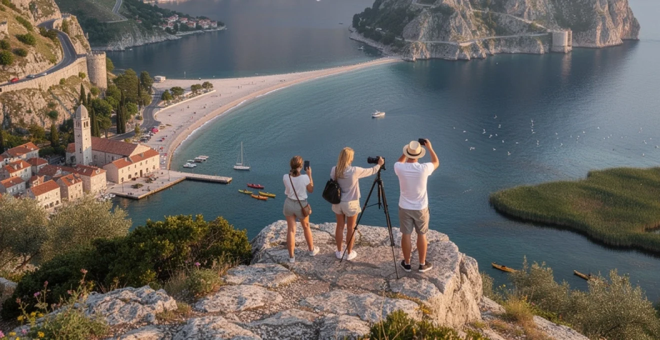
Kotor old town venetian architecture and medieval fortifications
While the Bay of Kotor impresses with its geological drama, Kotor Old Town adds a finely preserved cultural layer that has earned it UNESCO World Heritage status. Enclosed by thick stone walls that rise steeply into the surrounding cliffs, the city reflects centuries of Venetian influence in its architecture, street layout and public spaces. Narrow alleys open suddenly onto stone-paved squares where palaces with carved balconies sit opposite Romanesque churches, creating compositions rich in texture and detail. Because the old town is compact and largely traffic-free, you can easily explore with a camera in hand, moving from shaded passages to sunlit piazzas in a matter of steps.
Above the town, the medieval fortifications climb the mountainside in a zigzag of walls, gates and towers leading up to the San Giovanni fortress. The ascent—more than 1,300 steps—is as much a journey through history as a physical workout, with each switchback revealing a slightly higher perspective on the bay below. Photographers who tackle the climb at sunrise or during the golden hour are rewarded with soft, angled light that accentuates the bay’s fjord-like contours and the terracotta roofs of Kotor’s core. From the top, the view rivals any on the Adriatic: a sweeping amphitheatre of water, stone and sky that explains why this harbour has been coveted for millennia.
Biogradska gora primeval forest and virgin beech stands
Biogradska Gora National Park, though less known than Durmitor, protects one of the last remaining primeval forests in Europe and offers a very different type of scenic experience. Situated in the northeastern part of the country, the park’s virgin beech and fir stands have been largely untouched for centuries, allowing a complex, multi-layered forest ecosystem to flourish. Walking here, you experience the Adriatic hinterland as it might have looked long before modern development—a dense, cathedral-like woodland where fallen trunks are left to decay and mosses, fungi and ferns create an intricate green tapestry. For landscape photographers, the interplay of dappled light, towering trunks and reflective puddles after rain provides endless opportunities for intimate, detail-rich compositions.
At the centre of the park lies Biogradsko Lake, a glacial lake encircled by steep forested slopes that change colour dramatically with the seasons. In spring, fresh foliage creates bright green reflections, while autumn turns the scene into a blaze of copper, gold and crimson mirrored on the calm surface. A simple loop path around the lake allows you to experiment with different angles and foregrounds—roots, branches, boathouses—without strenuous hiking. In contrast to Montenegro’s rugged coastal cliffs, Biogradska Gora’s beauty is more subtle and immersive, inviting slower exploration and rewarding those who focus on textures, patterns and the quiet grandeur of an old-growth forest.
Lovćen national park njegoš mausoleum and serpentine mountain roads
Lovćen National Park occupies a symbolic place in Montenegrin identity and offers some of the most far-reaching coastal views in the entire Adriatic region. The park’s twin peaks rise abruptly above the Bay of Kotor and the old royal capital of Cetinje, creating a natural balcony where mountain and sea landscapes intersect. Atop Jezerski Vrh stands the Njegoš Mausoleum, dedicated to the 19th-century poet-prince Petar II Petrović Njegoš. Reached by a tunnel and a final staircase of over 400 steps, the mausoleum’s terrace reveals a 360-degree panorama that, on clear days, extends across much of Montenegro and even to neighbouring countries.
The approach to Lovćen is an experience in itself, thanks to a series of historic serpentine roads that ascend from the coast. These narrow, winding routes, originally engineered during the Austro-Hungarian period, coil up the mountainside in tight hairpins that gradually reveal more of the bay below. Driving them demands attention and patience, but the reward is a sequence of ever-expanding vistas where the Bay of Kotor shifts from a close-up harbour scene to a full-scale geographic map. For those interested in scenic drives and road-trip photography, Lovćen’s mountain roads encapsulate Montenegro’s defining characteristic: dramatic elevation changes compressed into very short distances.
Distinctive adriatic beaches and coastal formations
Montenegro’s beaches are markedly different from the long, uniform sand stretches many travellers associate with Mediterranean holidays. Instead, the Montenegrin Adriatic coastline is defined by a patchwork of pebbled coves, narrow sandy inlets and rocky platforms sculpted by centuries of wave action. This variety, combined with the region’s limestone geology, contributes to the Adriatic’s almost surreal water clarity, where stones and sea grass remain visible several metres below the surface. For those seeking the most scenic places to swim, snorkel or simply sit and watch the light change, this complexity is a major advantage.
Along the Budva Riviera, beaches such as Mogren, Bečići and Jaz demonstrate how sand and pebble segments are frequently framed by cliffs and headlands, creating natural amphitheatres rather than featureless shorelines. South of Budva, the iconic islet of Sveti Stefan is connected to the mainland by a narrow tombolo of pale sand and pebbles, forming one of the most photographed coastal compositions in the Balkans. Further down the coast, around Petrovac and Lučice, pine-fringed coves and offshore islets add additional layers to seascape shots, especially at sunrise and sunset. Even near larger towns, you can still find smaller, less developed bays where rocky shelves provide excellent platforms for diving into the Adriatic’s transparent water.
On the northern side of the Bay of Kotor, the coastline softens into a sequence of stone jetties, tiny urban beaches and waterside promenades where locals swim just a few steps from historic stone houses. Here, the line between built and natural environment blurs: terraced gardens descend directly into the bay, and church bell towers reflect on the water alongside mountain peaks. In the far south, near Ulcinj, Montenegro reveals yet another face with Velika Plaža, an extensive sandy beach over 13 kilometres long. This stretch, exposed to open sea swells and afternoon winds, has become a hotspot for kite-surfing and offers broad, minimalist seascape compositions that contrast sharply with the enclosed intimacy of Kotor Bay. Together, these coastal formations make Montenegro’s beaches not just pleasant places to relax, but highly varied subjects for Adriatic seascape photography.
Dramatic Mountain-to-Sea elevation changes and scenic drives
One of the most compelling reasons Montenegro stands out as the Adriatic’s most scenic destination is the immediacy with which mountains and sea meet. In many parts of the country, you can drive from coastal promenade to high alpine meadow in under an hour, experiencing temperature drops of 10–15°C and completely different ecosystems along the way. For travellers who enjoy scenic drives, this compressed geography translates into routes where each kilometre brings a noticeable change in perspective. Rather than long, gradual transitions, Montenegro offers a series of visual “gear shifts” that keep the journey as memorable as the destinations.
These rapid elevation changes also create natural viewports—terraces, bends and passes where the landscape suddenly opens and invites you to stop. In practical terms, it means that even short road trips can yield dozens of photographic opportunities, from tight canyon interiors to wide coastal panoramas. It also means, however, that drivers must be prepared for narrow roads, frequent hairpin turns and local driving habits that can feel assertive to visitors used to wider highways. Choosing a suitable vehicle, avoiding night driving on unfamiliar mountain roads, and allowing extra time for photo stops can transform these routes from stressful obligations into some of the highlights of your Adriatic itinerary.
Cetinje to budva mountain pass panoramic vistas
The road between Cetinje and Budva offers one of Montenegro’s classic mountain passes, linking the former royal capital with the Adriatic coast in just over 30 kilometres. Leaving Cetinje, the route climbs gradually through karst fields and low forest before reaching a series of lookouts where the terrain seems to fall away towards the sea. On clear days, the Adriatic appears as a broad blue band on the horizon, framed by rugged ridges and scattered hamlets. The contrast between Cetinje’s cool, inland plateau climate and Budva’s Mediterranean warmth becomes increasingly evident as you descend, with vegetation shifting from beech and fir to olives and cypress trees.
From a scenic perspective, what makes this pass especially appealing is the way it reveals the Budva Riviera in stages. Initially, you catch glimpses of coastline between rocky outcrops; later, the view widens to encompass the entire bay, Sveti Stefan and, further south, the outline of the Bar region. Pull-offs along the way provide safe spots to stop and photograph these evolving vistas without blocking traffic. Because the light changes dramatically between morning and afternoon, this route rewards travellers who are willing to drive it in both directions at different times of day. In doing so, you experience not only a practical connection between inland heritage and seaside resorts, but one of the most layered panoramic drives on the Adriatic coast.
Kotor serpentine road hairpin turns and fjord overlooks
Perhaps Montenegro’s most famous scenic drive is the historic serpentine road that climbs from the Bay of Kotor towards Njeguši and Lovćen. Often credited with having 25 distinct hairpins, this narrow, stone-framed route was originally constructed to connect Kotor with the interior before modern tunnels and highways were built. Today, it serves primarily as a scenic alternative rather than the fastest way inland, which suits photographers and road-trip enthusiasts perfectly. Each hairpin offers a slightly different angle on the bay below, gradually transforming the view from an intimate harbour scene to a full overview of Kotor, Perast and the surrounding mountains.
Because the road is both steep and constricted, careful driving and considerate passing etiquette are essential, especially in high season when campervans and tour buses also make the ascent. That said, designated lay-bys and wider sections allow you to stop safely and absorb the view without rushing. Standing at one of the upper bends, you can see why the Bay of Kotor is often compared to a Norwegian fjord: the water appears trapped between walls of grey limestone, its surface broken only by tiny villages and the twin islets near Perast. If you time your drive for late afternoon, when the sun drops behind the mountains, the bay takes on a deep blue tone while village lights begin to glow—a combination that produces some of the most atmospheric coastal images in Montenegro.
Durmitor ring road alpine lake reflections
In Montenegro’s north, the Durmitor Ring Road offers a different kind of scenic driving experience, circling the Durmitor massif and passing through high pastures, glacial valleys and remote villages. Unlike the tight stone serpentine above Kotor, this route is more open, with long sightlines and broad curves that reveal the mountain range from multiple perspectives. Elevations frequently exceed 1,500 metres, and in many sections you feel as if you are driving along the spine of the mountains themselves. On either side of the road, traditional katun settlements—seasonal shepherd huts—dot the landscape, underscoring how closely local life has been intertwined with this harsh but beautiful environment.
Several small alpine lakes and ponds, including the more remote Modro and Zminje lakes, can be accessed via short detours or hikes from the ring road. On calm days, these bodies of water provide perfect conditions for capturing peak reflections, with clouds and crags mirrored on their surfaces like carefully composed paintings. Because weather in the Durmitor area can change rapidly, planning flexible stops along the ring road is wise; you might encounter thick fog on one side of the massif and crystal-clear skies on the other. For those willing to rise early or stay out late, the combination of high altitude and minimal light pollution also makes this loop one of Montenegro’s best locations for night sky and Milky Way photography.
Montenegro’s photographic appeal compared to croatian and albanian coastlines
When travellers research the Adriatic, Croatia often dominates the conversation, with Albania increasingly gaining attention as an emerging destination. Montenegro, lying physically and visually between them, offers a compelling middle ground. Compared with Croatia’s long, island-dotted coastline, Montenegro’s shore is shorter but far more vertically dramatic, with steeper mountains plunging into the sea and fewer flat coastal plains. This compressed geography means that iconic viewpoints—such as the Kotor Bay overlooks, Budva’s citadel skyline, or Sveti Stefan’s islet—are concentrated within a relatively small radius, reducing travel time between major photo locations.
In contrast to Albania, where stretches of the Riviera are still in an early phase of tourism development, Montenegro has invested heavily in infrastructure and high-end accommodations while preserving much of its natural character. For photographers and independent travellers, this translates into easier access to mountain roads, national parks and coastal promenades without sacrificing the “untouched” feel that makes the Adriatic special. Think of Montenegro as the visual intensity of Croatia’s Dalmatian coast combined with some of Albania’s rawness, distilled into a country you can cross in a couple of hours. If you are asking yourself where you can experience the greatest variety of Adriatic scenery in the least amount of time, Montenegro consistently comes out ahead.
Another key distinction lies in how historical architecture interacts with the landscape. While Dubrovnik and Split offer monumental urban ensembles, Montenegro’s Kotor, Perast and Budva present a more intimate scale where fortifications and palaces are tightly integrated with cliffs and small harbours. The Bay of Kotor, in particular, provides compositions that are hard to replicate elsewhere: Venetian stone towns reflected in still, fjord-like water beneath 1,000-metre peaks. Albania, for its part, shines with sites like Gjirokastër and Berat, but these are inland rather than directly on the Adriatic. For travellers whose priority is coastal photography—where mountains, sea and historic architecture all share the same frame—Montenegro arguably delivers a higher density of “signature” shots than either neighbour.
Seasonal variations in montenegro’s adriatic landscape photography
Montenegro’s Adriatic landscapes are not static; they transform noticeably with the seasons, offering different moods and photographic opportunities throughout the year. In spring (April to early June), snow often still caps the higher peaks of Durmitor and Lovćen while coastal areas burst into bloom with wildflowers and fresh foliage. This duality—snowy summits above green hills and calm blue water—creates strong visual contrasts, particularly around Kotor Bay and Skadar Lake. Spring also brings more dynamic weather, with shifting clouds and occasional storms that can add drama to seascapes and mountain vistas without the crowds of high season.
Summer, from mid-June to early September, offers the most reliable sunshine and warm sea temperatures, making it ideal for travellers who prioritise swimming, boating and long days outdoors. The trade-off is increased visitor numbers, especially in Kotor, Budva and along the Budva Riviera, which can make minimalist landscape shots more challenging in busy locations. Yet even in peak season, early mornings and late evenings remain comparatively quiet and visually rewarding, with softer light and fewer boats on the water. If you plan ahead—choosing sunrise hikes above Kotor, late-afternoon drives up the serpentine roads, or evening boat trips on Skadar Lake—you can still capture the essence of Montenegro’s Adriatic coast without feeling overwhelmed by tourism.
Autumn (late September to November) is arguably the most underrated season for Adriatic landscape photography in Montenegro. As temperatures moderate and summer crowds thin out, forests in Biogradska Gora, Durmitor and around Skadar Lake shift into rich shades of red, orange and gold. The lower angle of the sun enhances textures on limestone cliffs and brings out subtle tones in old stone architecture. At the same time, sea temperatures remain comfortable well into October, allowing you to combine late-season swimming with mountain excursions under crisp, clear skies. For photographers who appreciate moody, atmospheric scenes, misty mornings over the bay or lake followed by sunlit afternoons are common at this time of year.
Winter brings a very different character, especially in the interior, where Durmitor, Bjelasica and other ranges receive reliable snowfall, transforming northern Montenegro into a compact winter-sports destination. While some mountain roads and high passes may be closed or require special equipment, accessible viewpoints near Žabljak and along cleared sections of highway provide opportunities to capture snow-covered peaks against deep blue winter skies. Coastal areas, meanwhile, remain relatively mild, often quiet and bathed in a softer, more diffuse light. If you have ever wondered what it would be like to photograph a nearly empty Kotor Old Town or a serene Budva citadel under winter sun, this is the season to find out. Across the year, Montenegro’s shifting conditions ensure that even repeat visitors will find fresh perspectives on what many consider the Adriatic’s most scenic destination.